#chilkat lake
Explore tagged Tumblr posts
Visit Tumblr Blog
Explore Tumblr blogs with no restrictions, modern design and the best experience.
Last Seen Tumblr Blogs


Fun Fact
If you dial 1-866-584-6757, you can leave an audio post for your followers.
Text

Chilkat Lake Sub 1st Additional Block #10-LOT 2, Haines, AK
3 notes
·
View notes
Photo


#vacation#alaska#travel#photography#Beautiful World#adventure#cruise#denali#chilkat lake#hubbard glacier#medenhall glacier#sunset#nature#travel photography
0 notes
Text

A bald eagle arrives to steal a perch on a tree log that offers a strategic view of the shoreline at the Chilkat Bald Eagle Preserve in Alaska. When other eagles drag freshly caught salmon in from the water, these bystanders swoop in to take a share. "Hours of observing their patterns and behavior helped me capture moments like these,” says photographer Karthik Subramaniam, a software engineer with a passion for wildlife photography. Photograph By Karthik Subramaniam

In May 2021, the Fagradalsfjall volcano erupted in the Reykjanes Peninsula in Iceland for the first time in over six thousand years. The lava flow continued for six months, spreading hard black rock across the landscape. It was, says Riten Dharia, who captured this image, "an exhibition of the raw and awesome power of nature." Photograph By Riten Dharia
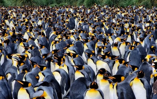
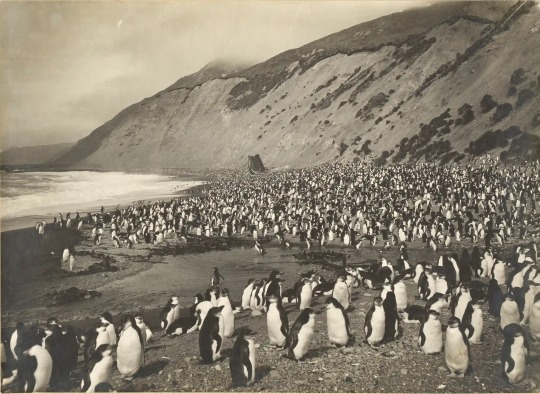
King penguins crowd together in the viewfinder of Rhez Solano on the beaches of Gold Harbour in South Georgia. The island sits in the remote southern Atlantic Ocean, not far from Antarctica, and hosts some 25,000 breeding pairs of king penguins, along with gentoo penguins, and elephant seals. Photograph By Rhez Solano
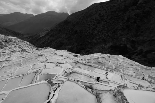
There are around 4,500 salt wells terraced into the hillside at the Salt Mines of Maras in Peru. The archaeological record shows that salt extraction likely began here before the Inca Empire, perhaps as far back as 500 AD. Today that tradition continues with the families who own wells, each of which produces some 400 pounds of salt per month. “The salt wells receive water through channels sourced by a salty underground spring nearby and once the water evaporates, the crystallized salt remains,” says An Li, who captured this picture. “Here, a salt miner is using a wooden rake to extract the salt." Photograph By An Li

Asiilbek, a nomadic Kazakh eagle hunter, preps his golden eagle, Burged, for a horseback hunt in the grasslands outside of Bayan-Ölgii, the westernmost province of Mongolia. The eagle’s training begins when fledglings are captured from their cliff edge nests and taught how to hunt for hare, fox, and even deer. The tradition stretches back 3,000 years. “For this image, I was lying on my stomach in the prone position looking through the electronic viewfinder at the edge of the stream,” says photographer Eric Esterle. “The ground shook as Asiilbek's horse passed less than a few feet away, splashing me with ice cold water. I remember covering my camera with my body and putting my head down.” Photograph By Eric Esterle
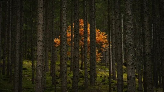
On a road trip through the Austrian Alps, Alex Berger spotted a one-lane road that wound into the mountains and looped back on the map. He followed it alongside a small stream lined with walls of forest when he spotted this golden tree blooming from between the trunks. There’s “a fantasy-ish inspired dimension for me,” says Berger, “which gives me goosebumps.” Photograph By Alex Berger
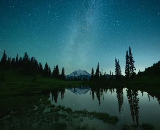
Sometimes a sleepless night is key to great photography. At approximately 3:40 a.m. on a frigid summer morning, photographer W. Kent Williamson snapped this image from Tipsoo Lake in Mount Rainier National Park, Washington. From across the still water, he could see a line of headlights as weary climbers approached the peak’s 14,411-foot summit—the culmination of a multi-day climb. "The night sky was unusually clear, and the Milky Way could be seen just above the mountain,” Williamson says. “I was surprised to see how bright the climbers’ lanterns were.” Photograph By W. Kent Williamson
From Frozen Memories: Rare Antarctic Expedition images! A royal penguin rookery at Nuggets Beach on Macquarie Island. Photographer and adventurer Frank Hurley went on multiple voyages but his best-known images were taken when the Endurance was crushed in the ice during explorer Ernest Shackleton’s 1914 expedition. Photograph: Frank Hurley
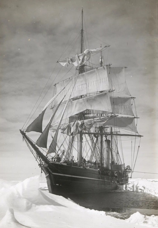
From Frozen Memories: Rare Antarctic Expedition images! The Terra Nova held up in pack ice during Robert Falcon Scott’s expedition to the Ross Sea and South Pole. Photograph: Herbert George Ponting
6 notes
·
View notes
Video
vimeo
Original caption:
“Ant[arctic]A And Beyond” is a small compilation of 4K footage I’ve shot throughout my expeditions, Artist In Residencies, and travels as a landscape and wildlife photographer. Starting with an incredible 1-month Antarctic expedition to the Falkland Islands (Islas Malvinas), South Georgia and the South Sandwich Islands, The South Shetland Islands, and the Antarctic Peninsula; followed by my Artist In Residency sailing the high Arctic on a Barquentine Tall Ship with Scientists and other Artists. No adventure is complete without including Alaska, a very special place to me, with footage and imagery from my work along the Chilkat River, Lake Clark National Park, as well as my Artist In Residency with the U.S. Forest Service in the remote designated wilderness areas of Kuiu and Tebenkoff Bay in the Tongass National Forest. I’ve also included a special piece from one of my favorite U.S. National Parks, Yosemite, with footage of the beautiful natural phenomenon known as the “Firefalls.” I close with some personal favorite images taken elsewhere to include the beautiful Great Gray Owl species (Strix nebulosa).
Some of the Southern hemisphere footage I shot in historically significant locations such as Elephant Island, and the resting place of Sir Ernest Shackleton in Grytviken, as well as incredibly remote wildlife locations such as Salisbury Plains and Saint Andrews Bay. Hiking in an active caldera at Deception Island to crossing the Drake Passage simply must be experienced to appreciate.
Sailing the high Arctic on a tall ship full of Scientists and Artists, you experience a collaboration with amazing people from around the world with one common appreciation for expressing the fragility of our natural world.
Legal: - All footage and still imagery is copyright © Eric Esterle ericesterle.com - All music used and listed in the credits is properly and legally licensed. - Public Domain Cylinder recording by Sir Ernest Shackleton is not copyrighted as it was not included in the Copyright Act of 1909 - Alan Watts recording licensed from alanwatts.com
#antarctica#penguin#arctic#ship#science#nature#travel#landscape#wanderlust#elephant island#geology#video#vimeo#the earth story
42 notes
·
View notes
Photo
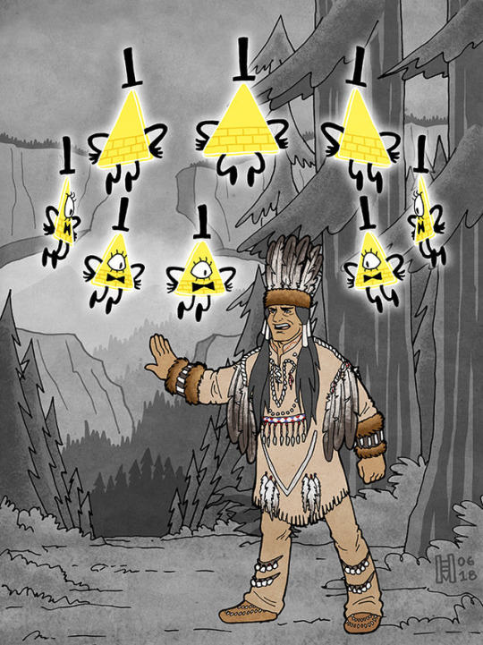
Bill and Modoc the Shaman (click to embiggen)
Another piece to celebrate the anniversary of the release of the Blacklight Journal 3 Special Edition! This time, Modoc the Shaman! I was excited to see a drawing in the blacklight Journal 3 of Modoc, and had been wanting to do something with him ever since.
The reasoning and research behind the way he is dressed, along with illustrations, is probably best put under a cut...
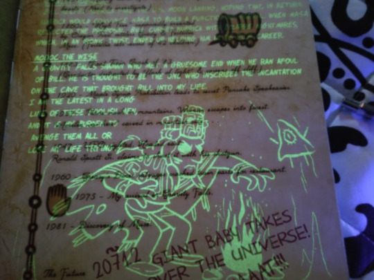
“Modoc the Wise. A Gravity Falls shaman who met a gruesome end when he ran afoul of Bill. He is thought to be the one who inscribed the incantation on the cave that brought Bill into my life. I am the latest in a long line of these foolish men, and it is my burden to avenge them all or lose my life trying.”
(Once again, indebted to @fordarkisthesuede for the pic of the blacklight Journal, and the transcription!)
I really appreciated that the design for Modoc was clearly based on NW Coast elements, rather than his being a "generic shaman" design. The only problem, though, was that the headdress and robe he is wearing is pretty clearly identifiable -- the headdress is a Haida chief's design, featuring a carved frontlet and ermine surround, while the robe looks a little like a Haida robe and a little like a Tlingit chilkat robe (it's hard to tell at that angle and in just linework; but the Tlingit did trade with the Haida).

(Above, Haida Chief Son-I-Hat John McAllister, 2016)
So on the one hand, it's great that the design is from roughly the right part of North America! (Rather than being a Plains design, for example.) However, the Haida and Tlingit are coastal tribes, from quite far north (along the coast in what is now British Columbia in Canada, and southeastern Alaska). And, Gravity Falls, as shown on maps in the show itself, is not coastal, and is located in at least central to south Oregon. The tribes in that area aren't the same, and they don't have the same artistic and design expression.
(I'm not counting the presence of the totem pole in the show. So-called totem poles are also more of a NW Coast thing, but, in modern times, they've become a lot more widespread throughout the region. And the show is a case of a white guy using the totem pole as decoration for a tourist trap, in which case, it not being exactly geographically authentic is completely to be expected.)
So I decided to see if I could figure out how Modoc the Shaman might have looked, with a bit more of a nod to customs local to the Gravity Falls area.
The first issue, of course, is that while we have a general idea of where Gravity Falls is supposed to be, we don't have an exact location. It's *probably* in the Cascades in central-ish Oregon, but we don't know how far to the north or south. It's probably not as far south as Crater Lake, and it isn't as far north as Mt. Hood. Otherwise...? *Handwave*. This makes a difference because the tribe whose lands comprise the north-central Cascades are the Molala, while the southern Cascades (into northern CA) are the Klamath (including the area around Crater Lake).
In the end, I wound up going with a Klamath shaman design for Modoc, for a few reasons:
Edward Curtis took a bunch of photos of Klamath men and women, including one shaman, in the early 20th century. So it's easier to find references for Klamath ceremonial dress.
I wasn't having much luck finding good references for the Molalla.
the show named the shaman “Modoc”.
The Modoc tribe is from the same region as the Klamath, and is affiliated with the Klamath Tribes today.
I based this design of Modoc the Shaman specifically on photos of Lee Snipes, otherwise known as "Captain Sky", one of the last practicing shamans of the Klamath (according to their own tribal website). He was photographed in several outfits, and I blended elements from them. To figure out the coloring, I was able to hunt down a website with pictures from what seems to be some Smithsonian holdings of historical Klamath clothes and decorations, in color. (The problem with trying to reconstruct historical costumes from black and white photos, obviously, is that you can fall into the trap of making everything too monochrome. In this case, I felt a little more certain by the end that the outfit probably WAS fairly monochrome in earth tones, with some stand-out red and blue design elements, based on the historic clothing samples.)

(Above, my two main references. Both Lee Snipes / Captain Sky, taken by Curtis ca. 1923. Snipes was photographed in a variety of outfits. There are a few more photos of him, in which accessories vary but some basic design elements remain the same. It seems likely -- though I don’t know for sure -- that Snipes himself was selecting the outfits for the photos. I’m making an assumption, however, that these reflect what he would have worn for ceremonial purposes as a shaman.)
The other issue with figuring this out is that Modoc the Shaman is supposed to be from far in the past - 1000 CE. It's not ideal to be attributing what is essentially a modern design to a far-past historical figure -- that is, it's not great to suggest that a Native American tribe's ceremonial dress was static in design across centuries, when we know that almost all traditional designs evolve even if the culture is trying to keep to a tradition. So I just want to acknowledge that as problematic. Just because we know what a Klamath shaman was wearing in the early 20th century, we can't necessarily say that a shaman from the same region was wearing the same things 500 or 1000 years earlier. So, this is a good-faith effort to be more authentic to the region, but, with an acknowledgement of its limitations.
(At least we do know that the Klamath, or a form of that tribe, were living in the area for a very long time. When I visited Crater Lake, a ranger gave a presentation that included the fact that it's now been acknowledged by historians that Klamath oral tradition includes what are basically mythologized eyewitness accounts of the eruption that formed Crater Lake... 10,000 years ago.) So there you go! This was an interesting exercise, and I like the results.
Finally, I should note: elements of this piece should be recognizable as a combination of screenshot-redraw modifications, most notably from The Last Mabelcorn. The background is also based on some screenshots.
428 notes
·
View notes
Text
Alaska Cabin for Sale - High Roller Homes
If you’re on the lookout for a remote and cozy cabin in Alaska, this might just be the one for you. This cabin, located on the Little Lake in Chilkat Lake Recreation area, is up for sale. It boasts of a full finished loft with a retractable ladder, …
source https://www.highrollerhomes.com/alaska-cabin-for-sale/
0 notes
Text
My fellow African Americans please research your family trees. Don’t fall for this rhetoric about you not having Native ancestry
That’s to keep you misinformed and unaware of your rights and programs that you may qualify for. Why do you believe that others of African descent are capable of having mixed ancestry but somehow 500 years+ in this land & we get ridiculed if we claim our native ancestry?? Below is the state-by-state list of reservations. This is your country, not only because of the slave labor that built (and continues to build) it but also because of the native blood that runs through your veins 🎋♥️
http://www.ncsl.org/research/state-tribal-institute/list-of-federal-and-state-recognized-tribes.aspx
Alabama
Poarch Band of Creeks
Alaska
Native Village of Afognak (formerly the Village of Afognak)
Agdaagux Tribe of King Cove
Native Village of Akhiok
Akiachak Native Community
Akiak Native Community
Native Village of Akutan
Village of Alakanuk
Alatna Village
Native Village of Aleknagik
Algaaciq Native Village (St. Mary's)
Allakaket Village
Native Village of Ambler
Village of Anaktuvuk Pass
Yupiit of Andreafski
Angoon Community Association
Village of Aniak
Anvik Village
Arctic Village (See Native Village of Venetie Tribal Government)
Asa'carsarmiut Tribe
Native Village of Atka
Village of Atmautluak
Atqasuk Village (Atkasook)
Native Village of Barrow Inupiat Traditional Government
Beaver Village
Native Village of Belkofski
Village of Bill Moore's Slough
Birch Creek Tribe
Native Village of Brevig Mission
Native Village of Buckland
Native Village of Cantwell
Native Village of Chenega (aka Chanega)
Chalkyitsik Village
Cheesh-Na Tribe (formerly the Native Village of Chistochina)
Village of Chefornak
Chevak Native Village
Chickaloon Native Village
Chignik Bay Tribal Council (formerly the Native Village of Chignik)
Native Village of Chignik Lagoon
Chignik Lake Village
Chilkat Indian Village (Klukwan)
Chilkoot Indian Association (Haines)
Chinik Eskimo Community (Golovin)
Native Village of Chitina
Native Village of Chuathbaluk (Russian Mission, Kuskokwim)
Chuloonawick Native Village
Circle Native Community
Village of Clarks Point
Native Village of Council
Craig Community Association
Village of Crooked Creek
Curyung Tribal Council
Native Village of Deering
Native Village of Diomede (aka Inalik)
Village of Dot Lake
Douglas Indian Association
Native Village of Eagle
Native Village of Eek
Egegik Village
Eklutna Native Village
Native Village of Ekuk
Ekwok Village
Native Village of Elim
Emmonak Village
Evansville Village (aka Bettles Field)
Native Village of Eyak (Cordova)
Native Village of False Pass
Native Village of Fort Yukon
Native Village of Gakona
Galena Village (aka Louden Village)
Native Village of Gambell
Native Village of Georgetown
Native Village of Goodnews Bay
Organized Village of Grayling (aka Holikachuk)
Gulkana Village
Native Village of Hamilton
Healy Lake Village
Holy Cross Village
Hoonah Indian Association
Native Village of Hooper Bay
Hughes Village
Huslia Village
Hydaburg Cooperative Association
Igiugig Village
Village of Iliamna
Inupiat Community of the Arctic Slope
Iqurmuit Traditional Council (formerly the Native Village of Russian Mission)
Ivanoff Bay Village
Kaguyak Village
Organized Village of Kake
Kaktovik Village (aka Barter Island)
Village of Kalskag
Village of Kaltag
Organized Village of Kasaan ... to be continued
#i could only fit Alabama in this post#click the link#african american#african americans#native american#native americans#reservations#tribe#tribal#american indians#maroons#afro native#mine are from fayette county alabama#they just sold our land 😢#check census records#kmow your ancestry
1 note
·
View note
Photo

Went to the Alaska for the first time recently expecting amazing scenery. Was not disappointed. Chilkat Lake near Haines, AK [8573x4877]
2 notes
·
View notes
Photo

#Earth Went to the Alaska for the first time recently expecting amazing scenery. Was not disappointed. Chilkat Lake near Haines, AK [8573x4877]
1 note
·
View note
Photo

Went to the Alaska for the first time recently expecting amazing scenery. Was not disappointed. Chilkat Lake near Haines, AK [8573x4877] Check this blog!
1 note
·
View note
Text

Chilkat Lake Sub 1st Additional Block #10-LOT 2, Haines, AK
2 notes
·
View notes
Photo

Went to the Alaska for the first time recently expecting amazing scenery. Was not disappointed. Chilkat Lake near Haines, AK [8573x4877] via /r/EarthPorn http://ift.tt/2uoHwRD
1 note
·
View note
Photo

Went to the Alaska for the first time recently expecting amazing scenery. Was not disappointed. Chilkat Lake near Haines, AK [8573x4877] via /r/EarthPorn http://ift.tt/2uoHwRD
0 notes
Video
vimeo
Original caption:
A week of exploring on the road to Haines, Alaska. We hiked, camped and explored in Kluane National Park, Tatshenshini-Alsek Provincial Park, Chilkat state Park, Chilkoot Lake state Park.
Music by Eluvium
#alaska#mountain#glacier#mountains#kluane national park#Tatshenshini-Alsek Provincial Park#drone#chilkat#chilkoot#geology#video#travel#waterfall#vimeo#the earth story
68 notes
·
View notes
Photo

Went to the Alaska for the first time recently expecting amazing scenery. Was not disappointed. Chilkat Lake near Haines, AK [8573x4877] via /r/EarthPorn http://ift.tt/2uoHwRD
0 notes
Text
Packing It In
[Saturday, July 27]
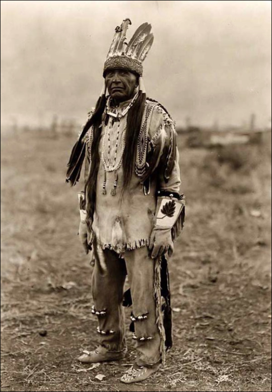
Saturday morning was not the prettiest morning on record but at least it was not raining. Following breakfast, we were picked up and driven up the Haines Highway along the Chilkat River to the Jilkaat Kwaan Heritage Center. Members of the Klingit tribe awaited us and showed us around their ancestral home. Correction, their ancestral home was the size of Connecticut; now they sadly have all of 3 square miles. I am getting very lazy in my writing so again, I will simply quote from their website on how this Heritage Center came to be, opening in Spring of 2016.


“In the 1970’s a movement toward the culture began to take place. In 1976 the Chilkat Indian Village Tribal Government passed an ordinance preventing the sale or removal of clan trust property without the knowledge and approval of the tribal government. The return to the culture was slow in progressing at first but really began to pick up some momentum after the Klukwan Healing Robe was started in the fall of 1992 and the Whale House Trial was held in 1993. A plan to build the Jilkaat Kwaan Cultural Heritage Center began to take shape when the village held a strategic planning session in January of 2002. The Heritage Center is helping to address the village/clan’s pressing issue of where to put the precious clan treasures that are no longer housed in clan houses and the community’s desire to rebuild and restore our cultural heritage.”


Pictured below are strips of salmon that were caught and prepared by kids at camp earlier in the week. Once it becomes shiny, then it will be smoked.

Clan members/guides traded off as we walked outside. I thought they were all a little awkward in their presentations but they will get better with time. They only have about 90 residents in the area but are committed to saving and building their culture. Considering Indian children used to be punished when they spoke their language at school, Klingit is now offered in the public school for anyone to learn. We also were invited in to the clan house where they danced, sang and told us a story about how the world got fresh water. We were allowed to take photos but no recordings of stories or songs.

We were also instructed to not repeat any of the stories because they would only be paraphrased versions instead of the exact stories passed down from tribal story tellers. After walking around outside, we were also given a guided tour of the exhibits inside the cultural center and given the chance to visit their gift shop. It was an honor to visit here and I am glad it was a part of our itinerary not eliminated due to the ferry issues.
Our next stop was on the bank of the Tsirku River at a rafting put-in area.

We divided into 2 groups, donned life preservers and rubber boots and boarded 16-foot rafts. This was the easiest raft trip we have ever been on as we had to do no work. Only the guides paddled! Southeast Alaska is suffering from drought so the rivers were low and maneuvering was challenging. There were times we could feel the bottom of the river under our feet. From the Tsirku River, we joined the Chilkat River and could see Klukwan on the far bank.


Eagles were everywhere......everywhere!


As the salmon have begin their run and with the low water levels, it was a salmon smorgasbord for the eagles and ravens. Again we were hoping also to see bears or moose along the shorelines but no such luck. At one spot, our two guides ran out rafts aground so we could watch the eagles’ behavior when one of them had a salmon and the rest of them wanted it. Soon after, our float was over and we were enjoying our own picnic by the river.


Back at the hotel, we had about an hour or so to relax (ha!) and get ready for an afternoon hike in Chilkat State Park.

The skies did not look promising but we all soldiered on and ended up with bouts of sunshine and rain, so either way, we were pleased to be under the cover of the old growth forest. We walked out to Battery Point which took us along a beach curving around the Lynn Canal for a portion.


Isn’t this plant fascinating?


Robin, the Conqueror.

Carrie was always taking pictures so I had to capture one of her!

It was a relatively busy trail with some good elevation changes so good exercise, too. We had one guide always in the lead and one guide (and bus driver) always behind the group.

When we stopped for a snack, we were amazed at all the food (salmon spread, crackers, energy bars, cookies, fruit leather) and drinks (coffee and hot chocolate) they pulled out of their backpacks. That was a couple of strong young women. Contracting with these adventure companies has its rewards.

When we returned to Fort William H. Seward, Janet and I made sure we made time to grab the walking tour brochure and circled the parade ground, reading the guide and the historic markers along the way. Basically every building in the complex needs some TLC but it must be tough with the restrictions and regulations that come with living and doing business in a designated Historic Area.


Like the eagles earlier on the river, we enjoyed a nice salmon dinner at the hotel. I am actually not a fan of salmon. My only exposure to it while growing up was the salmon cakes my mom would fry using canned salmon. Other times when I had tried it as an adult, it was just too fishy tasting. People kept telling me if I had “good” salmon, I would like it. On this trip, I ate “good” salmon several times so I can no longer say I don’t like it. (I even shocked Janet by liking the smoked salmon we had with bagels and cream cheese on one of our kayak trips.)

Believe it or not, after dinner, we still had one more scheduled tour and it wasn’t to the fair or the distillery. Rain had really set in for the evening — it probably rained for the next 12 hours, which the area really needed — and we felt bad for the fair goers. Our rafting guide had been looking forward to his volunteer stint serving beer Saturday night at the fair. That tent was covered as was the main stage so I imagine a little rain was not going to deter these hearty Alaskans. And what about us Road Scholars? Hearty as well. Off we went.
We boarded the same outfitter’s bus with the same driver but with an older female guide who talked a mile a minute and had her comedy and tour guide routine down flat. She lives in Pittsburgh but this is the second summer she has come to Alaska working as a tour guide. We were allegedly going to have privileged access to a road ending at Chilkoot Lake, about 10 miles out of town. Ha! When we got there, despite the heavy rain, there were people everywhere — in vehicles, walking along the road, fishing from the bank and fishing from the middle of the Chilkoot River. We had hoped to see bears coming for easy dinner pickings from the salmon whose upstream swim had been temporarily halted by the weir (or dam) but we saw none. There may have just been too much humanity around.

An Alaska Department of Fish and Game employee was still out on the weir at his counting station but closed up for the day as darkness was closing in.

We had already seen his daily “count” board.......

...... and he was getting ready to update it but stopped and talked to us. He quit his regular job in Anchorage to take this job and he said it was because, “I just love fish.”

Everyday during the salmon run, he removes 10 fish for testing. By scraping scales and examining them, they can tell the age of the fish. He counts every fish coming through the gate in the weir but by far, the majority are salmon, specifically sockeye when we were there. (I am writing this 8 days after our visit. The total count is now up to 120,000 but the flow has slowed way down so that run is about over.) I imagine the bears are fat and happy.....but not me. It was time to leave Alaska.
1 note
·
View note